

New York’s $119 Billion Mega Sea Wall: The Enormous Plan to Hold Back the Atlantic
New York City has spent generations engineering its way around water.
Tunnels run beneath rivers. Artificial land extends Manhattan beyond its original shoreline. Bridges, subway tubes, highways, airports, ports and skyscrapers occupy territory shaped by one of the most complex urban waterways in the United States.
But one proposal considered after Hurricane Sandy would have taken New York’s relationship with the ocean to an entirely different scale.
The concept called for an enormous storm-surge barrier stretching across the entrance to New York Harbor, potentially connecting the Sandy Hook area of New Jersey with the Rockaway Peninsula in Queens. Depending on the iteration being studied, enormous movable gates would allow ships and tides to pass during normal conditions before closing when a major coastal storm approached.
The estimated lifecycle cost attached to the most ambitious version reached approximately $118–$119 billion.
It quickly became known as New York’s proposed $119 billion sea wall.
The description is dramatic, but it is also somewhat misleading. The project was never simply a concrete wall sealing New York off from the Atlantic. It was one of several alternatives investigated by the U.S. Army Corps of Engineers as part of the much larger New York-New Jersey Harbor and Tributaries Study.
More importantly, the $119 billion barrier is not currently an approved $119 billion construction project. The Army Corps' planning process has evolved substantially since that figure attracted national attention around 2019 and 2020.
Yet the idea remains important because the problem it attempted to solve has not disappeared.
If anything, New York's race against the water is becoming more urgent.
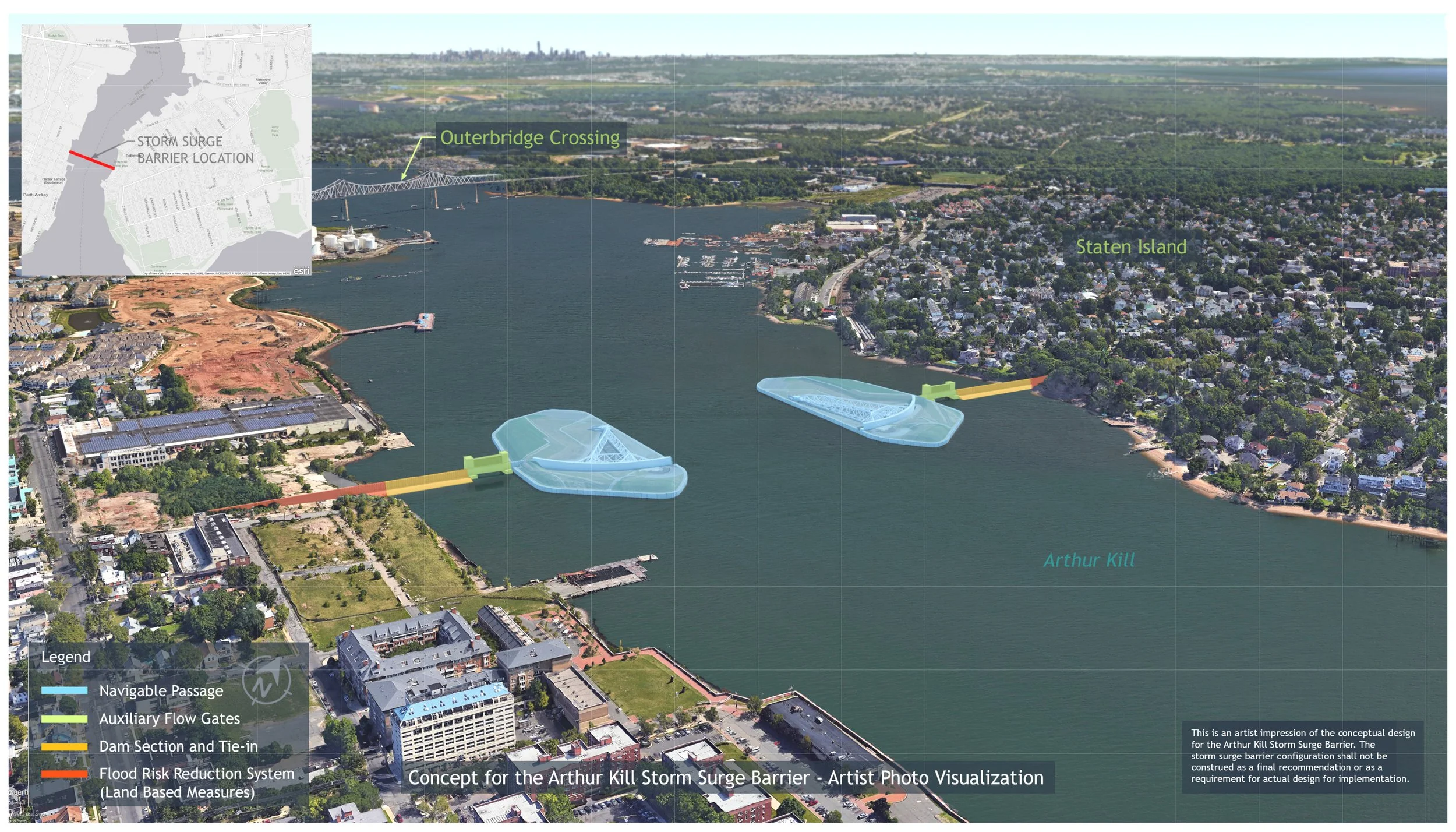
Use an official U.S. Army Corps NYNJHATS rendering or diagram showing one of the regional storm-surge barrier concepts. This is the strongest lead image because it immediately communicates the enormous scale of the engineering proposal.
The Storm That Changed New York
To understand why engineers would seriously investigate infrastructure costing more than some countries' annual economic output, it is necessary to return to October 29, 2012.
Hurricane Sandy pushed an extraordinary storm surge into New York Harbor.
Water poured into neighborhoods, electrical infrastructure failed, transportation systems shut down and tunnels filled with seawater. According to New York City, Sandy killed 44 New Yorkers and caused approximately $19 billion in damages and lost economic activity.
Approximately 51 square miles of the city flooded, representing around 17 percent of New York City's landmass. Nearly 90,000 buildings were within the inundation zone, while millions of residents lost electrical power.
The storm exposed an uncomfortable weakness in America's largest city.
Much of New York's infrastructure sits remarkably close to sea level.
Source: NYC Mayor's Office – Hurricane Sandy: The Storm & Impacts
https://www.nyc.gov/assets/sustainability/downloads/pdf/publications/Sandy-10-Years-Later.pdf
Source: NYC Office of Resiliency – Sandy Impacts
https://www.nyc.gov/site/orr/challenges/sandy-impacts.page
Subway tunnels, electrical equipment, residential neighborhoods, highways, wastewater infrastructure and commercial districts all occupy areas susceptible to coastal flooding.
Sandy demonstrated what can happen when the geography that helped create New York's economic power becomes a liability.
The city's waterways effectively became pathways for the storm.
And planners knew Sandy would not necessarily remain an isolated event.
Designing a Gate Across New York Harbor
After Sandy, the federal government began examining coastal vulnerability across the northeastern United States.
The U.S. Army Corps of Engineers' North Atlantic Coast Comprehensive Study identified several areas requiring further investigation, including the New York-New Jersey Harbor and its tributaries.
That eventually led to the New York-New Jersey Harbor and Tributaries Coastal Storm Risk Management Feasibility Study, commonly abbreviated as NYNJHATS.
The geographical scale of the study is enormous.
It includes all five boroughs of New York City, New York Harbor, Jamaica Bay, Newark Bay, Raritan Bay, portions of western Long Island Sound and tidally influenced rivers extending well beyond the immediate city.
Source: U.S. Army Corps of Engineers – New York/New Jersey Harbor & Tributaries Focus Area Feasibility Study
https://www.nan.usace.army.mil/Media/Fact-Sheets/Fact-Sheet-Article-View/Article/2495552/fact-sheet-new-yorknew-jersey-harbor-tributaries-focus-area-feasibility-study/
Engineers considered several approaches.
Some involved local floodwalls and shoreline improvements.
Others involved smaller storm-surge barriers protecting individual waterways.
And then there was the giant.
One early alternative investigated an approximately five-mile storm-surge gate between Sandy Hook, New Jersey, and Breezy Point in Queens.
The Army Corps described an estimated lifecycle cost of approximately $118 billion for the concept, including operation and maintenance.
Source: U.S. Army Corps of Engineers – New York & New Jersey Harbors and Tributaries Study Interim Report
https://www.nan.usace.army.mil/Media/News-Stories/Story-Article-View/Article/1785119/new-york-new-jersey-harbors-and-tributaries-study-interim-report-on-display-at/
Media coverage subsequently rounded the enormous figure to $119 billion.
The proposal would have been among the most ambitious coastal engineering projects ever contemplated in the United States.

The flooded Brooklyn-Battery Tunnel is one of the clearest visual examples of why New York began seriously considering enormous coastal-defense projects after Hurricane Sandy.
It Wouldn't Really Be a “Wall”
Calling the concept a sea wall creates the image of an uninterrupted concrete structure separating New York from the ocean.
That wasn't quite the engineering idea.
New York Harbor is one of the busiest maritime gateways in North America. Permanently closing it would obviously be impossible.
Any regional barrier would therefore require massive navigable gates.
During ordinary weather, those gates would remain open, allowing ships, tides and water to move through the harbor.
When meteorologists predicted a dangerous storm surge, the gates could close.
For a limited period, New York Harbor would effectively become a protected basin.
The engineering concept has international precedents.
The Netherlands uses enormous movable barriers as part of its Delta Works system. London is protected by the Thames Barrier. Venice has developed the MOSE system to temporarily isolate its lagoon during dangerously high tides.
New York's challenge, however, would be extraordinary.
The harbor is enormous, heavily trafficked and environmentally complex.
Any barrier would need to accommodate container ships, passenger vessels, ferries and other maritime traffic while surviving decades of saltwater exposure, waves, currents and extreme storms.
This would not merely be a wall.
It would be a gigantic piece of movable infrastructure sitting at the entrance to one of the world's most economically important metropolitan regions.
Why Would Anyone Spend $119 Billion?
The price is staggering until it is compared with what sits behind the proposed barrier.
New York City's current coastal exposure is immense.
In July 2026, the city said nearly 440,000 New Yorkers, 14,500 businesses and approximately $250 billion in property value are located within the city's 100-year floodplain.
Source: NYC Mayor's Office – Expansion of the Bureau of Coastal Resilience, July 24, 2026
https://www.nyc.gov/mayors-office/news/2026/07/mayor-mamdani-announces-major-expansion-of-the-bureau-of-coastal
The potential losses also grow as sea levels rise.
New York City says sea level could rise by as much as another 5.4 feet by 2100. The city estimates that by the 2050s, an event associated with a roughly once-in-70-year loss could produce approximately $168 billion in damages in current dollars, even without additional development in the floodplain.
Source: NYC Mayor's Office of Climate & Environmental Justice – Coastal Surge Flooding
https://www.nyc.gov/content/climate/pages/coastal-surge-flooding
That changes the economics of coastal protection.
A $119 billion defense system sounds almost impossibly expensive.
But repeated disasters affecting hundreds of billions of dollars of buildings and infrastructure could become even more expensive.
The question is therefore not simply whether New York can afford enormous coastal defenses.
It is whether New York can afford the consequences of failing to build enough protection.
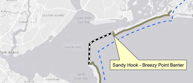
An aerial or satellite-style view helps readers understand just how enormous the proposed outer-harbor barrier would have been. The concept studied by the Army Corps crossed the Sandy Hook–Breezy Point area and had to accommodate several major navigation channels.
The Problem With Building a Giant Gate
There is another side to that calculation.
Storm-surge barriers are extremely good at addressing one particular problem: storm surge.
They do not automatically solve every type of flooding.
New York increasingly faces multiple water threats simultaneously.
Heavy rainfall can overwhelm drainage systems from inside the protected area. Rivers and tributaries can flood. Groundwater levels can rise. Ordinary high tides become increasingly problematic as sea levels increase.
A giant harbor barrier might stop a Sandy-like surge from entering parts of the region, but it cannot simply make rainwater disappear.
There are also serious environmental considerations.
New York Harbor is an estuarine ecosystem in which saltwater and freshwater interact. Restricting tidal movement, even temporarily, requires careful study of potential effects on water quality, sediment movement, wetlands and marine habitats.
Then there is the problem of geography.
A barrier protecting one portion of the harbor can potentially alter water behavior elsewhere. Coastal defense at this scale cannot simply push water toward another community.
That is one reason the Army Corps' study became much broader than the headline-grabbing image of one enormous wall.
The $119 Billion Wall Is Not the Current Plan
This distinction is crucial.
Someone encountering the "$119 billion New York sea wall" online today could easily conclude that New York is preparing to begin construction on a $119 billion barrier across the harbor.
That is not the current status of the project.
The enormous outer-harbor barrier belonged to an earlier set of alternatives.
By September 2022, the Army Corps released a Draft Integrated Feasibility Report and Tier 1 Environmental Impact Statement identifying a different tentatively selected approach known as Alternative 3B.
Instead of one gigantic barrier across the outer harbor, that concept relied on a system of smaller storm-surge barriers and shoreline defenses.
The 2022 plan included barriers associated with Jamaica Bay, Arthur Kill and Kill Van Kull, as well as barriers at Gowanus Canal, Newtown Creek and Flushing Creek. Shore-based measures were also proposed in locations including Jersey City, Lower Manhattan and East Harlem.
The estimated initial construction cost of that alternative was approximately $52.7 billion, according to later Army Corps documentation.
Source: U.S. Army Corps of Engineers – New York-New Jersey Harbor and Tributaries Draft Integrated Feasibility Report / Tier 1 Environmental Impact Statement
https://www.nan.usace.army.mil/Portals/37/NYNJHATS%20Draft%20Integrated%20Feasibility%20Report%20Tier%201%20EIS_3Oct2022.pdf
Source: U.S. Army Corps of Engineers – Draft Integrated Interim Response Feasibility Report and Environmental Assessment, July 2025
https://www.nan.usace.army.mil/Portals/37/NAN%20-%2005%20-%20NYNJHATS%20-%20Draft%20Report%20-%20Draft%20Report%20V3_1.pdf
Even that approach has continued to evolve.
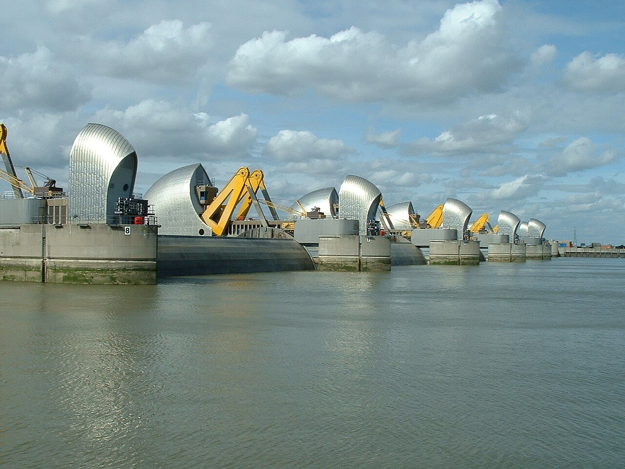
The Thames Barrier gives readers a real-world example of what movable storm-surge infrastructure looks like. It visually reinforces your explanation that New York's concept would have been a sophisticated system of navigable gates rather than a solid concrete wall.
Where the Project Stands in 2026
The latest chapter is considerably less dramatic than constructing a wall across the Atlantic entrance to New York Harbor, but it may ultimately be more practical.
In July 2025, the Army Corps released a Draft Integrated Interim Response Feasibility Report and Environmental Assessment for Actionable Elements.
Rather than waiting for the entire regional strategy to become construction-ready, the report examined localized projects that could move forward sooner.
Source: U.S. Army Corps of Engineers – Draft Integrated Interim Response Feasibility Report and Environmental Assessment for Actionable Elements, July 24, 2025
https://www.nan.usace.army.mil/Media/News-Releases/Article/4254722/us-army-corps-of-engineers-announces-release-of-draft-integrated-interim-respon/
As of March 2026, the Army Corps reported that its Draft Final Interim Integrated Feasibility Report and Environmental Assessment for Initial Actionable Elements, along with a proposed Chief of Engineers report, had entered state and federal agency review.
According to the Corps, the next process involves finalizing the Chief of Engineers report before transmission through the Assistant Secretary of the Army for Civil Works to Congress.
Source: U.S. Army Corps of Engineers – New York-New Jersey Harbor and Tributaries Study, March 2026 Update
https://www.nan.usace.army.mil/Missions/Civil-Works/Projects-in-New-York/New-York-New-Jersey-Harbor-Tributaries-Focus-Area-Feasibility-Study/
In other words, the famous $119 billion mega-barrier remains an important chapter in the history of New York's climate-defense planning, but presenting it as a currently approved project would be inaccurate.
The real story is arguably more interesting.
New York has moved from debating whether it needs massive coastal protection to figuring out what combination of infrastructure can realistically be designed, funded, approved and constructed.
New York Is Already Building Its Defenses
While the regional Army Corps strategy continues through planning and review, New York is already spending billions on smaller coastal-resilience projects.
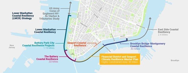
The East Side Coastal Resiliency project represents one of the largest examples. The city says the approximately $1.45 billion system will use raised parkland, floodwalls and 18 swinging or sliding floodgates to create a continuous line of protection for more than 110,000 people on Manhattan's Lower East Side.
Meanwhile, Lower Manhattan is undergoing its own transformation.
In June 2026, New York announced completion of the first phase of the $200 million Battery Coastal Resilience project, which is rebuilding and elevating sections of The Battery's waterfront.
That project belongs to more than $2.7 billion in Lower Manhattan Coastal Resiliency investments.
Source: NYC Mayor's Office – Battery Coastal Resilience Project, June 8, 2026
https://www.nyc.gov/mayors-office/news/2026/06/mayor-mamdani-completes-first-phase-of-battery-coastal-resilienc
The result is something fundamentally different from one colossal sea wall.
New York is gradually constructing a network.
Floodwalls.
Raised parks.
Deployable gates.
Elevated waterfronts.
Drainage improvements.
Smaller surge barriers.
And potentially, eventually, larger regional defenses.
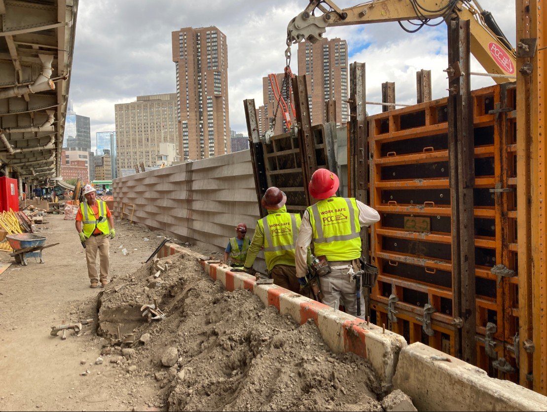
Workers construct the floodwall system associated with East Side Coastal Resiliency along Manhattan's East River. Unlike the enormous outer-harbor barrier, projects like this demonstrate the more localized approach New York is already implementing.
The Construction Challenge Could Last Generations
Protecting New York from the ocean is not likely to be a single megaproject with a ribbon-cutting ceremony and a clear finish line.
It may instead become a permanent category of infrastructure.
Roads require resurfacing. Subway systems require modernization. Bridges require maintenance.
New York's coastline may increasingly require the same continuous investment.
The city has approximately 520 miles of shoreline, and in July 2026 it announced an expansion of its Bureau of Coastal Resilience to oversee a growing portfolio of flood-protection infrastructure.
That alone demonstrates how dramatically the conversation has changed since Sandy.
Coastal resilience is no longer an experimental planning exercise.
It is becoming part of the city's basic infrastructure.
Source: NYC Mayor's Office – Bureau of Coastal Resilience Expansion, July 24, 2026
https://www.nyc.gov/mayors-office/news/2026/07/mayor-mamdani-announces-major-expansion-of-the-bureau-of-coastal
Workers construct the floodwall system associated with East Side Coastal Resiliency along Manhattan's East River. Unlike the enormous outer-harbor barrier, projects like this demonstrate the more localized approach New York is already implementing.
A $119 Billion Warning
The most significant thing about New York's $119 billion mega sea wall may ultimately be that it is never constructed.
The proposal demonstrated the extraordinary scale of infrastructure that engineers were willing to investigate after Hurricane Sandy exposed New York's vulnerability.
It also forced an uncomfortable calculation into public view.
How much is protecting New York worth?
A $119 billion storm barrier would rank among the largest infrastructure investments in American history. But the property, infrastructure and economic activity exposed to coastal flooding are worth vastly more.
And the threat is moving in only one direction.
Sea levels are rising. Hundreds of thousands of New Yorkers already live within flood-risk areas. Critical infrastructure built during an era of relatively stable coastlines must now operate in an environment its original designers never anticipated.
The engineering response is consequently becoming more ambitious.
The spectacular vision of a giant movable wall across New York Harbor may have faded from the immediate plan, replaced by a more distributed network of surge barriers, floodwalls, elevated landscapes and neighborhood-scale defenses.
But the underlying idea remains.
For most of its history, New York built infrastructure to conquer geography.
During the coming century, it may have to spend just as much engineering infrastructure to defend itself from it.
